More about the English Lakes
| More about the English Lakes |
Not far south of Emperor Hadrian's impressive attempt to control our Scots
cousins the Romans developed a networks of roads and forts across the rugged
English Lakes. The Romans erected the 84-mile Hadrians
wall nearly 2,000 years ago and it is now both a World Heritage site and
new official signposted long-distance footpath. The most dramatic remains of
the Roman occupation are those of Hardknott Fort (Pictured) overlooking Eskdale
valley.
Another dramatic and challenging
"Roman experience" can be enjoyed by walking in the
footsteps of the legions across the mountain that became called
High Street in recognition of this old roman road that links Penrith
and Ambleside.
In 13th century it was called the Brethstrett, in respect of the Britons of
Cumbria.On ridge at over 2,000 feet. Summit of High Street has even been used
as a racecourse. It dips into the dramatic Straights of Riggindale and then
up onto High Raise heading north, eventually gently descending Loadpot Hill
towards Tirril for Penrith. Ambleside fort (Galava was built around 90 AD) while
Brocavum (Brougham) was built 80-81AD by Agricola. Despite its great height
it represents the walkers best route.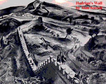 The regulation Roman
army rate was 20 miles in five hours. At the start Eamont Bridge provides two
inns. A bronze age circular mound is known as King Arthur's Round Table. Before
the moorland start the village of Tirril furnishes an inn and small store.Out
onto the moors and soon one of many middle bronze age stone circles is passed.
Thereafter steady climb past Arthur's Seat. High Raise starts the more dramatic
mountain section South of High Street the roman road could have taken the distinct
terrace path down towards Troutbeck, a route known as Scots Rake, no doubt in
respect of its use as
The regulation Roman
army rate was 20 miles in five hours. At the start Eamont Bridge provides two
inns. A bronze age circular mound is known as King Arthur's Round Table. Before
the moorland start the village of Tirril furnishes an inn and small store.Out
onto the moors and soon one of many middle bronze age stone circles is passed.
Thereafter steady climb past Arthur's Seat. High Raise starts the more dramatic
mountain section South of High Street the roman road could have taken the distinct
terrace path down towards Troutbeck, a route known as Scots Rake, no doubt in
respect of its use as  route
by the Scots at some stage in history. But an alternative route for the roman
road could have been tracing the ridge south skirting Froswick and Ill Bell
before descending to the Garburn Pass. An ancient map does show short lengths
of "roman road" on Yoke at 436062. More
details on the High Street route.
route
by the Scots at some stage in history. But an alternative route for the roman
road could have been tracing the ridge south skirting Froswick and Ill Bell
before descending to the Garburn Pass. An ancient map does show short lengths
of "roman road" on Yoke at 436062. More
details on the High Street route.
The route from Amblesides roman fort to Ravenglass
is marked on the ancient Antonine Itinerary, the first AA road map!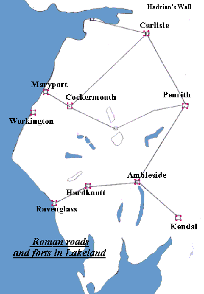
In 1920 near to the Little Langdale to Tilberthwaite footbridge and ford R.G.
Collingwood saw a section of 10 foot wide road complete with kerb stones.In
1946 Ian Richardson, author of the Penguin classic on Roman Britain
did detailed field studies at Wrynose and Hardknott. The roman road is on a
shelf some 75 yards above the present road until the two come together to breast
the rise and pass the Three Shire Stone. After taking a more gradual descent
than the present roasd the romans then ran a straight line to the north of the
infant Duddon. This 24 foot wide causeway is clearly visible in parallel with
the tarmac road. After Cockley Beck the romans headed down valley to Black Hall.
From near the farm it then zig zags up to the head of the pass. On the descent
to Eskdale the roman route goes straight on when the modern road takes a vertigous
sharp turn left. The roman route had its own zig zags down from Hardknott fort
to just south of Brotherilkeld. The roman route from Penrith via a fort at Troutbeck
clearly indicates a fort at Keswick, with Castlerigg being an obvious contendor
for the site.A roman route went over Whinlatter descending Scales Hill into
Lorton.
Gallery of images from
the 2012 archaeological dig at Derventio (Cockermouth) Guidance on the Roman
Papcastle.
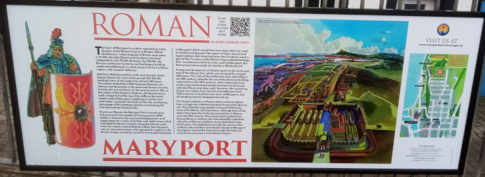
Latest on the 2014 excavation of Roman settlement
at Maryport..More
details..
New in 2017: GB and Irish Iron Age
Hillforts database and map.
Don't forget to see Maryport's
Roman Museum if you are looking for a wet weather idea.
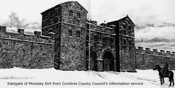 Along
the Cumbrian coast were a string of forts at Maryport, Workington, Moresby (See
artist's impression) and Ravenglass.
Along
the Cumbrian coast were a string of forts at Maryport, Workington, Moresby (See
artist's impression) and Ravenglass.
Walkers are now able to follow the entire length of Hadrian's Wall across northern
England for the first time in 1,600 years. There is plenty of signposting along
the spectacular 84-mile Roman route from Bowness-on-Solway in Cumbria to Wallsend,
Tyneside. The Countryside Agency has developed 30 miles of new rights of way
to follow the wall's path, along with new gates, footbridges and stiles. The
work has also opened up stretches of the World Heritage Site for disabled access.Parts
of the wall have always been open to the public but since the Romans left, there
has been no unbroken right of way to follow its route.
|
TAXIS for exploring Hadrians
Wall. As is common
with major excavation projects run by United Utilities, archeologists
were drafted in at an early stage of the pipeline programme, in case any
important finds were made while digging on the land. Alison Plummer from
Oxford Archeology, who led an 18-strong excavation "This settlement would have been used by the unofficial wives and children of soldiers in the nearby fort, along with traders and craftspeople. The discovery offers some enticing clues as to how our ancient ancestors spent the cold Cumbrian evenings. "The beautiful and ornate jewellery also indicates that people took alot of care over their appearance. These items are likely to have been worn by women of considerable social standing." The landscape surrounding Brougham and Hackthorpe is steeped in ancient history, with a high concentration of Prehistoric and Roman monuments. September 2008: Historians always predicted there was a Roman presence in the Keswick area and now the underground remains of an ancient structure the size ofeight football pitches has been found. The site, two miles east of the town and close to the famous Castlerigg stone circle was almost certainly a base for soldiers campaigning north of the Border or resting on their return. Summer 2009: CUMBRIAN archaeologist, Professor Clifford 'Indiana' Jones gets very angry at the neglect of the site of Workington's Roman fort. Where once Roman soldiers used to keep watch over the River Derwent estuary and the harbour now lies partly beneath a disused railway area and close to Dunmail Park shopping centre. In true TimeTeam style, the professor wants the history of the Roman fort known as Burrow Walls excavated and researched. He says: "It is time to stir the earth and see what wonders lie beneath, to inspire future generations by our discoveries." The Workington Roman fort was part of the chain of forts that made up the world famous Hadrian's Wall between Newcastle and Cumbria. Contrary to the school text book view professor Jones thinks the wall was less of a military barrier and more aimed at tax and customs collection for the Roman Empire. He says; "It a frontier built for taxation and prevention of cattle rustling." This
fort along with another at Moresby are part of the Hadrianic frontier,
therefore they are part of the World Heritage site. He adds: "I can
think of no more forgotten a piece of heritage than Burrow Walls. Its
treatment "Community archaeology is the thing - getting the local population involved in their history - this site is as much there site, indeed mores so than the archaeologists and academics. The occupants of the housing estate that sits next Burrow Walls are probably unaware that they reside next to an archaeological site that directly connects to them, not only to the rest of the Hadrianic system in Britain but to a frontier that encompassed the entire Roman Empire. Yet this wonderful gift of a portal into the past and potentially an educational and commercial boost for the community is simply forgotten; a pile of stones in a field." "As
a professional archaeologist working in west Cumbria I have spent many
years building up a volunteer workforce, there being no point in suggesting
excavation without personnel to carry it out. The use of "If
the Burrow Walls site was excavated and presented to the public I believe
it would both add to our knowledge of the past and benefit the present
and future, attracting people to view the site would aid the New publicationin 2012 by Dr Jones: Hadrians-Wall-Walking-Guide |
Copyright © Lakestay All rights reserved.
 Nov 2008:Rare Roman discovery brings ancestors' past to life A rare Roman
settlement has been unearthed near Penrith in Cumbria, shedding light
on the life and times of the region's ancient settlers
Nov 2008:Rare Roman discovery brings ancestors' past to life A rare Roman
settlement has been unearthed near Penrith in Cumbria, shedding light
on the life and times of the region's ancient settlers